Summer Learning Series: Travel Across the Curriculum with Google Earth

The next edition of my summer learning series features my all time favorite technology experience (notice I didn’t use the word tool). Google acquired Keyhole Earth Viewer in 2004 and was launched as Google Earth in 2005. Since then, I have been obsessed with discovering everything I ever wanted to know about our planet’s physical features, or specific destinations I know I’ll never get around to visiting on an educator’s budget. I recently put together a resource for K-12 teachers that showcases how you can support classroom instruction across the curriculum utilizing Google Earth Pro, Web and App. The presentation begins with basic navigation skills for all 3 versions and goes into more detail with advanced features such as Voyager, Street View, creating tours, and toggling between Moon, Sky and Mars.

There are numerous slides that allow you to practice the skills referenced in the video tutorials. Towards the end of the presentation, each curriculum area has specific examples of lessons that allow you to see the power of Google Earth in the classroom. Click here to make a copy of the presentation below. 

WARNING: Once you discover how cool Google Earth is, you will spend many, many hours of your summer vacation traveling to exotic locations. 

Tour the Earth with Voyager

Google Earth Voyager is a great way to get lost and quickly lose about 3-4 hours of your day if you’re not careful. Their partners, including National Geographic, PBS, and The Ocean Agency, have created a collection of map-based stories that’s updated weekly. Topics include travel, culture, nature, history and education. Students can enter a 360 photo sphere of the coral triangle located in Raja Ampat to view an incredibly rich center of biodiversity, or travel back in time to explore the evidence from around the world that finally explained the disappearance of dinosaurs.

There are many expeditions to choose from and many are relevant to elementary curriculum. I’ve gathered some of these together on an interactive Thinglink image. Hover over each pin icon to open a Voyager adventure. 

My favorite one has to be Celebrating Harry Potter. Below is an Explore, Explain, Apply HyperDoc that includes this voyage in the explain section. Click here to make a copy.

The Ultimate Google Survival Guide Facelift

As with any online tool, change is inevitable, especially with Google. Modifications to platforms are, for the most part, positive even though there might be a slight learning curve for the end user. Google Classroom recently came out with several new features that teachers will love. You can read about them here. One of my goals this summer was to become Google Certified. As I was studying for the exam, I realized I hadn’t updated my Ultimate Google Survival Guide in quite a few years, and it needed a huge facelift. It’s more of a curated list of resources from various sites, but hopefully it will keep you from hopping all over the Internet to find the best of the best. Each tool includes tutorials from Hoonuit (login required), Google Training Center, Google Help Center, and links to Google Innovator’s blogs like Alice Keeler, Eric Curts, and Kacey Bell. If you teach Littles, make sure to check out resources from the amazing Christine Pinto.

I also wanted include instructional ideas to go along with the video tutorials that demonstrate the basics. You will find several examples of embedded content like Thinglink or Google Maps that provide ideas for implementation. This is a dynamic resource that I will add to on a regular basis as I discover or create lessons throughout the year. Enjoy!

What’s New in Google Earth?

Back in April, Google announced they would be revamping their entire Google Earth experience. That’s great news if you are a Chromebook user as Google Earth can now be viewed right from your browser. But those aren’t the only changes to this amazing platform. About 10 years ago I started creating my own virtual field trips for students. It was a very time consuming process, and I didn’t have access to embeddable interactive content. Google now has a component full of interactive experiences from around the world called Voyager. These are curated journeys from all over the world that include Street View images and 360 degree videos. There are 6 categories for students to choose from:

One of my favorites was created by PBS Education called Explorers: Age of Encounter. Students are able to travel back in time to the late 15th and 16th centuries and follow the routes of 6 explorers that changed the way people viewed the Earth and interacted with each other from different countries and continents.

One way to turn this into a collaborative project would be place students into 6 groups using Alice Keeler’s Group Maker for Spreadsheets.  Each group can choose an explorer to research and document their findings in the spreadsheet. Once research is complete, the class can create one collaborative Google Presentation explaining how these encounters set the course for the modern, globally interdependent world. Increase the DOK level by asking them to describe an alternative history had these explorers not discovered new worlds and civilizations. There are many guided tours available, so I encourage you to check out this section by clicking on the ship’s wheel icon located on the navigation toolbar on the left.

Here are more resources about other new features in Google Earth and ideas for implementation:


Standard V Lesson Examples


Beginning with the 2013-2014 school year, NEISD teachers will be required to submit 1 student product that was created using technology. This initiative supports the Standard V requirements as outlined by SBEC.

My El Dorado peeps have been very busy planning with me and wanted to take this opportunity to share some of the projects they will be doing with their students. Many of these app/web tools are cross-curricular and can be applied to different TEKS or units of study. Please contact me if you have an idea for a lesson and need a similar task card to use with your students.

  • Kinder Language Arts K.6A identify elements of a story including setting, character and key events: Facetalk Retelling
  • 1st Grade Math 1.3 The student applies mathematical process standards to develop and use strategies for whole number addition and subtraction computations in order to solve problems: Farmyard Math
  • 1st Grade Language Arts 1.9 A Describe the plot (problem and solution) and retell a story’s beginning, middle, and end with attention to the sequence of events:  BME Summaries
  • 2nd Grade Science 2.5D Combine materials that when put together can do things that they cannot do by themselves such as building a tower or a bridge and justify the selection of those materials based on their physical properties: Videolicious Structures Project
  • 2nd Grade Science 2.5B  The student knows that matter has physical properties and those properties determine how it is described, classified, changed, and used. Matter and Energy Digital Story
  • 3rd Grade Reading SE 3.16 Students use comprehension skills to analyze how words, images, graphics, and sounds work together in various forms to impact meaning.  Students will continue to apply earlier standards with greater depth in increasingly more complex texts: Big 6 Research Project-PDF, Big 6 Research Project-Word 2013
  • 3rd Grade Math 3.11B: The student directly compares the attributes of length, area, weight/mass, and capacity, and uses comparative language to solve problems and answer questions. Perimeter Party
  • 4th Grade History 4.3 The student understands the importance of the Texas Revolution, the Republic of Texas, and the annexation of Texas to the United States: Google Tour Builder
  • 5th Grade Science 5.8 Students will understand that weather represents the short term conditions of the atmosphere by producing a video that explains weather patterns of a specific region over a 3 week period: Videolicious Weather Project


Tool of the Month: Google Tour Builder

Inspired by Williams Sonoma Pork of the Month Club (who doesn’t love a new pork product every month?), I bring you Tool of the Month Club. The idea behind these posts is to showcase new online tools or apps with ways to support the curriculum. I’ve decided to start with December because I have no patience and can’t wait until January to share the new Google Tour Builder. For years, Google Earth has been my favorite lab activity and now the Tour Builder is even easier to use. The beauty of any great tool is the ability to be cross-curricular and support multiple grade levels. The following resource was created to support the 4th grade Social Studies TEK: (3)  History. The student understands the importance of the Texas Revolution, the Republic of Texas, and the annexation of Texas to the United States. Click here for a printable version of the Texas Revolution project which also includes links to video tutorials. Since 4th grade also focuses on writing, Google Tour Builder is perfect for place-based storytelling. Students can design a story/path around a pigeon or crow that flies to different locations around the world bringing messages to different characters. For math, multi-step word problems can be written and solved based on distances between area schools or cities.  Check out the video below for a great overview.

Geo Greeting for Spelling Practice

Geo Greeting is a neat little tool that allows you to create a message that contains up to 40 characters. It uses satellite images of buildings from all over the world that look like letters. The link it creates can be posted on your blog or emailed. It doesn’t generate an html code for embedding, but you can create a screen recording like the one below (AC/DC background music not included). This would be a fun way for students to practice spelling words. All the links can be submitted using a Google Form. It would also be a great way for primary students to chant word wall words.

November Themed Lessons

(If you are viewing this post from within NEISD, make sure to override Lightspeed so you can see the above video from YouTube)

It’s a new month, which means a new holiday, which means new themed technology lessons. Of course, I have to begin by sharing a Thanksgiving Google Doodle from last year. (Remember that you have to override Lightspeed to view the video from within the district.) The following list contains free sites and apps that you can use in the classroom or computer lab. My favorite lesson you should try is the Thanksgiving Timeline virtual field trip using Google Earth. I taught this a few times last year and it will take at least 2 lab visits to complete.  It’s well worth the time investment!

Google Maps Engine Lite – Scotland Style

I’ve been taking part in an online Mapping with Google course mainly to learn how to use Google Maps Engine Lite. I must say I’ve been at my computer for 2 days straight. One of our assignments was to create a custom map on a topic of our choice. I’ve been missing Scotland and felt compelled to share my favorite points of interest with the world, so… here it is! Expect many more posts on using Google Maps Engine Lite in the classroom.

Timelapse Video in Google Earth

As many of you know, Google Earth is one of my favorite cross-curricular tools to use with students. They recently added a timelapse feature that makes it possible to view changes in the Earth’s surface over a period of time. Click here to read more about it.

In the example above, students can explore a global timelapse video of our planet, constructed from Landsat satellite imagery. The Columbia Glacier is retreating at a rapid rate. Each frame of the timelapse map is constructed from a year of Landsat satellite data, constituting an annual 1.7-terapixel snapshot of the Earth at 30-meter resolution. The Landsat program has been acquiring images of the Earth’s surface since 1972. Landsat provides critical scientific information about our changing planet. How can this new feature enhance your Google Earth placemarks? They can be embedded! Simply right click on the timelapse video you would like to use and select “inspect element”. Copy and paste the highlighted HTML code into your placemark. Below is a screenshot of a placemark I created and some follow-up questions for students. More featured sites can be found here: http://earthengine.google.org/#intro


Columbia Glacier


A Thanksgiving Timeline Via Google Earth

The following activity takes some VERY cool interactive websites and combines them with my absolute favorite web tool, Google Earth. At the bottom of this post is the KMZ file I created along with a printable copy of directions. Enjoy!!!

To access the Google Earth tour:

  • Students login to Active Directory and open Google Earth
  • Go to File>Open and navigate to the Student Shared Drive
  • Click on the KMZ file named A Thanksgiving Timeline (teachers need to save the KMZ file to the student shared drive prior to teaching the lesson.)
  • You will see the tour on the left side of the screen. There are 7 place marks total with information and links to online activities.

  • Double click on the red letter in the left pane to advance to each location. Double click on the red letter in the center to view the content within the placemark.

  • Advance through each placemark while completing each interactive until students reach the final destination where they describe family customs and traditions celebrated by their own families.
  • Students can document their learning by filling out a timeline graphic organizer or they can directly comment inside each placemark by right clicking and choosing properties. This will open the placemark for editing purposes. When complete, simply right click on the Thanksgiving Timeline folder located in the left panel and choose Save As.

The following links are possible extension activities:

A Thanksgiving Timeline KMZ (Google Earth File)

A Thanksgiving Timeline Directions

Free Digital Timeline Maker

A Thanksgiving Timeline Recording Sheet

Windcrest Kinders Travel to Africa

During the week of April 16, the Kindergarten at Windcrest Elementary used Google Earth to travel to Africa in search of animal adventure. Our first destination was Lion Park, South Africa. They used their “binoculars” to get a close up look at a lion’s body parts and how they help him survive in the wild. Then they used Switchzoo to create an animal of their own and design a habitat to support its basic needs.


Our second destination took us to Timbe Elephant Park where we learned how the elephant uses his trunk in various ways. The students completed a Kidspiration activity where they used their “trunk” to paint a picture like a very special elephant from Thailand.


Our final destination was Cameroon, Africa, home to the world’s largest frog. We learned what a frog looks like during each stage of his life cycle by viewing an interactive tutorial from Harcourt School.


While visiting each location in Africa, the students filled in their research using a Passport. Below you will find the Google Earth KMZ and Passport used in this virtual field trip. Other Google Earth virtual field trips can be found on my Teacher Web. Please let me know if you are interested in creating a virtual field trip for your grade level.

Kinder Safari

kinder vft passport


My Favorite PowerPoint Lesson!

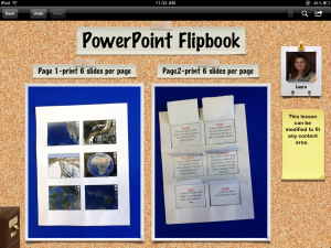
I LOVE THIS LESSON!  In the new NEISD world of iDevices and Web 2.0 tools, I’m always telling teachers not to forget about the world of PowerPoint.  This isn’t your everyday, boring slideshow.  This is a really cool fun foldable that can be used with any subject matter.  It can be created from scratch or can be saved as a template for younger grades to use.  Here is an example of what a completed project looks like using images from Google Earth:

You can use this template for multiplication facts, animal adaptations, parts of a cycle, scientific process….on and on!  Below you will find a blank template with directions, the Google Earth example you see above, and the landforms template.

LandformFlipbook_Final Product

LandformFlipbook_Template

Question and Answer Filpbook_Blank